Abstracts – Posters
FLASH PRESENTATIONS – TUESDAY, JULY 3
Pauline Donceel-Voûte, Université catholique de Louvain
Civitas IOB identified : Kanatha / Carneas / D’Noba in Southern Syria
Job lived in the Land of Hus (Aramaic, as in the Vulgata) or Ausitides (Greek Septuagint). The City of Job, Civitas Iob, where he lived and suffered what Satan inflicted upon him with God’s permission, is also called Carneas in Egeria’s Latin letters. Eusebios’ Greek indications equally give Karnaia, in Arabia, as the place where Job lived. Moreover, he writes that Kenath-the Roman Kanatha was the ancient town of Nabau/Noba –i.e. in Aramaic d’Nabau/D’Noba– ; this explains the Greek name Dennaba in the Septuagint, which Egeria uses when she indicates that « Carneas, the Civitas Iob in Ausitides, was previously named Dennaba ». Her (4th century) pilgrimage report writes about her visit to Job’s tomb, to the memoria of the dungheap which was the place of the Holy Man’s sufferings, to his house, as well as to the fountain where he cleansed himself at the end of his ordeal, according to non-biblical sources. All medieval and modern travellers to ancient Kanatha, nowadays Qanawât, have equally been shown there one or several of these places where Job is still worshipped. The grandest and still most visited is the Dêr Eyoub or Nebi Ayoub or Seray with its two basilical churches, peristyle court, colonnades, porticoes and basalt paved esplanade, near the city’s southern gate and walls ; the raised podium and crypt of its triconch martyrium, previously enclosed and vaulted, may be suggested as the place of the venerable sterquilinium.
Anna Chok, Institut de Recherche sur l’Architecture Antique (IRAA) – USR 3155 (AMU-CNRS)
Khirbet el-Libneh :un ensemble suburbain de vestiges paléochrétiens près de Tartous (Syrie)
Les travaux archéologiques menés, entre 1998 et 2009, dans la zone industrielle de Tartous (sur la côte syrienne) ont permis la découverte d’une partie d’un ensemble protobyzantin nommé « Khirbet el-Libneh ». Ma thèse, soutenue en 2015 à l’Université d’Aix-Marseille, a été consacrée à l’étude architecturale et archéologique de ce site. Cette recherche doctorale a permis d’établir qu’il s’agit probablement d’un secteur appartenant à un village ou à une bourgade à égale distance de 5 km de la ville d’Antarados (Tartous) et de l’île d’Arados (Arouâd). Dispersées sur un terrain de 11400 m², la plupart des structures appartiennent à la phase protobyzantine. Elles comprennent, côté est, une grande salle basilicale, le sol étant orné d’une mosaïque géométrique et doté d’une petite cuve dont l’étude soulève plusieurs difficultés (CHOK 2016, XVI CIAC Rome 2013, pp. 1591-1606). Vers l’ouest se trouvent une citerne et un complexe agricole composé de pressoirs à huile, de petits fours à pain et d’un moulin. Parmi le petit matériel mis au jour, on peut compter des fragments de céramiques, des pièces de monnaies, des objets en métal et en terre cuite et des restes humains. Un des objets les plus originaux est un tampon (ou une matrice) dont l’empreinte représente une image chrétienne d’un saint dans l’attitude de l’orant. Il a pu, entre autres, servir à marquer des jetons eulogiques. On s’interrogera donc sur la vocation possible de ce site archéologique paléochrétien et sur l’éventuel rapport avec le pèlerinage.
Giovanna Ferri, Pontificio Istituto di Archeologia Cristiana
I programmi decorativi degli edifici e delle vasche battesimali fra centro e periferia: ricezione dei modelli ed elaborazioni regionali
Il rito del battesimo necessita fin dalle origini, per la sua dinamica rituale, di spazi e strutture con caratteristiche specifiche, adeguate al suo svolgimento e al suo ruolo di fondamento e collante della comunità cristiana. L’intervento si propone di analizzare le scelte decorative ed iconografiche che caratterizzano l’articolazione e l’allestimento degli spazi dedicati al rito dell’iniziazione, siano essi edifici autonomi, ambienti annessi ad una basilica oppure esclusivamente bacini in marmo, metallo o terracotta, nel tentativo di evidenziare i rapporti – ora stretti e ben riconoscibili, ora labili e appena percettibili – tra i centri propulsori e le aree periferiche dell’Impero. Si cercherà, infatti, di rilevare non solo e non tanto la diffusione in tutto l’orbis christianus antiquus dei modelli iconografici formulati nei principali centri, a partire da Roma, Milano e Costantinopoli, ma soprattutto le rielaborazioni peculiari di ciascuna area geografica, dalla penisola iberica alla Gallia, al limes danubiano e renano, alla Britannia, all’Africa del Nord, per arrivare al Vicino Oriente. Se, infatti, in alcuni casi le “citazioni” degli apparati decorativi – come pure delle forme architettoniche – sono ben evidenti, in altri si assiste a sintesi, reinterpretazioni oppure a sistemazioni completamente autonome, che possono essere correlate alle peculiarità liturgiche assunte dal rito nelle diverse regioni, alle esigenze della comunità locale, nonché ai modi e ai ritmi dell’urbanizzazione e della conversione al Cristianesimo nel frammentato panorama delle aree liminali dell’Impero.
Maria Domenica Lo Faro, Università di Catania
La circolazione di immagini oltre i confini: scene di caccia e scene di spettacoli tra oggetti di uso quotidiano e programmi decorativi monumentali
Nel contributo si prendono in esame esemplari di lucerne con decorazioni figurate riconducibili a scene di spettacolo o di venationes rinvenute in contesti cimiteriali siciliani tardo antichi sia collettivi che di committenza privata. Partendo dall’illustrazione dei suddetti esemplari di lucerne che mostrano decorazioni di questo genere, vengono considerati i richiami tra queste raffigurazioni e i programmi decorativi di ampio respiro di alcuni monumenti tardo antichi tra aree centrali e aree periferiche, in particolare si propongono confronti con gli apparati decorativi musivi siciliani e nordafricani, e si esaminano rappresentazioni tematicamente affini presenti su oggetti preziosi e di pregio, quali dittici eburnei, vetri incisi, gemme, allo scopo di tracciare, in via ipotetica, il percorso della circolazione di particolari programmi decorativi anche attraverso la diffusione di immagini stereotipe raffigurate su oggetti legati all’uso quotidiano. Viene vagliata la possibilità di una diffusione capillare di modelli di rappresentazione iconografica nell’immaginario collettivo, forse veicolata da oggetti di facile trasporto e uso comune, che potevano agevolmente dare luogo a forme di imitazione artigianale e ripetizioni mnemoniche.
Dimitri Cascianelli, Pontificio Istituto di Archeologia Cristiana
Il sarcofago di Giona di Belgrado e le immagini del profeta nelle regioni di confine
Il sarcofago di Giona del Museo Nazionale di Belgrado costituisce la sola testimonianza nota dell’arte paleocristiana della Moesia. Nella fronte, tra due volute norico-pannoniche, è raffigurato un articolato apparato figurativo, incentrato sulla fortunata combinazione iconografica “Pastore-Giona”, un accostamento tematico assai diffuso nell’arte cristiana dell’origini. Questo binomio, infatti, si riscontra non solo nella pittura catacombale, nelle statuette di Cleveland o in una lucerna di Berlino, ma specialmente in alcuni sarcofagi prodotti tra la seconda metà del III e gli inizi IV secolo, come negli esemplari di S. Maria Antiqua, di Copenaghen, di Berlino o nel celebre sarcofago di Giona del Pio Cristiano, fornendo, dunque, un’importante indicazione cronologica per la “rilavorazione cristiana” dell’arca di Belgrado, attualmente riferita alla seconda metà del IV secolo.
Il sarcofago di Belgrado, tuttavia, mostra alcune particolarità iconografiche che meritano di essere approfondite. Mi riferisco ad alcune originalità della storia di Giona, come la presenza di un albero abitato da un volatile in luogo della cucurbita, o la curiosa immagine di un puttino a cavallo di un delfino, un dettaglio dedotto dal repertorio dell’arte musiva, il quale sembra richiamare anche gli amorini del ciclo di Giona del mosaico pavimentale della basilica teodoriana di Aquileia.
Dopo aver affrontato l’esame del sarcofago di Belgrado, il contributo tenterà di comporre un repertorio delle immagini del profeta nelle province limitanee dell’Impero – Africa, Egitto, Siria e Palestina, area balcanica e danubiana nonché i territori sul limes germanico -, soffermandosi particolarmente su quelle iconografie che si discostano dai comuni e reiterati esempi romano-italici.
Konstantinos T. Raptis, Hellenic Ministry of Culture, Ephorate of Antiquities of Thessaloniki
Remarks about the existence of galleries above the lateral aisles of the Early Byzantine basilicas of the Illyricum; a theorem to be either proved or contradicted
In most handbooks of Early Byzantine Architecture, the galleries are considered as main features of the basilicas erected in areas of Constantinopolitan influence, as in Asia Minor and the Illyricum. Contrariwise, they are absent from the basilicas built in the western provinces of the Empire. Even though the examples of basilicas without galleries are numerous in Italy, the generally accepted existence of galleries in the basilicas of the Illyricum remains unproved, based mainly on three standing monuments: Studios basilica in Constantinople, Acheiropoietos and Saint Demetrius basilicas in Thessaloniki.
However, based on recent studies, Acheiropoietos was originally erected without galleries; these were added to the original building during a seventh century restoration, after which the basilica functioned as cathedral. Furthermore, it seems that the galleries above the external aisles and the transept of Saint Demetrius basilica were added during the middle Byzantine period to the seventh century building. On the other hand, based on various architectural nonconformities the original existence of galleries above the inner aisles of the same basilica could be disputed. Thus, Stoudios basilica, with its rare arrangement with marble architraves, remains the only known Early Byzantine basilica with undisputable galleries.
Did all the Early Byzantine basilicas of the Illyricum have galleries? Or, did galleries exist only in Episcopal basilicas, as well as in some with special status of ktitoria? Were the galleries accessible to the congregation or restricted for special services, associated with the presence of the ecclesiastical hierarchy and/or representatives of the imperial court?
This paper discusses the existence—or not—of galleries above the lateral aisles of the Early Byzantine basilicas of the Illyricum, and attempts to either prove or contradict this not yet debated theorem of Early Byzantine Architecture.
Josipa Baraka Perica, University of Zadar, and Jona Petešić, Telašćica Natural Park
Il sito Gruh –Sv. Ivan dentro il parco naturale di Telašćica
Il sito presentato con questo poster si trova sul territorio del parco naturale di Telašćica, sull’isola di Dugi otok, situata vicino alla città di Zadar. Si tratta di un’area sottoposta a continue campagne di scavo, organizzate dall’Universitàdi Zadar in collaborazione con l’Ente regionale di gestione del Parco naturale di Telašćica. In questa sede saranno esposti i risultati delle ultime due campagne di scavo, che hanno attestato la presenza di una chiesa paleocristiana con continuità d’uso fino ad epoca basso medievale (sottoposta ad una breve campagna di indagine negli anni ‘50 del secolo scorso), costruita sopra una villa romana probabilmente quando questa era già in fase di abbandono. Insieme ai risultati degli scavi sarà presentata anche la topografia di questa zona del parco, con tutto lo splendore della natura presente.
Josipa Baraka Perica, University of Zadar, and Mirko Rašić, University of Mostar, Bosnia ed Herzegovina
Il sito Doci in Bosnia Erzegovina: una chiesa paleocristiana riscoperta
Il sito Doci in Bosnia Erzegovina: una chiesa paleocristiana riscopertaIn questo poster saranno presentati i risultati degli scavi di revisione del sito “Doci-bazilika”, situato in Bosnia e Erzegovina presso Doci, che si trova vicino al villaggio di Vitina, nel territorio del comune di Ljubuški. Il sito è stato scavato per la prima volta nel 1956, mentre i primi resoconti delle indagini archeologiche sono stati pubblicati solamente nel 1959. Alla luce di alcune scoperte casuali nella zona e lo scavo di un altro sito “paleocristiano” attiguo alla basilica (2014), si è presentata la necessità di organizzare uno scavo di revisione (2015), che ha permesso di riscoprire la basilica con tutta una serie di modalità insediative altrimenti sconosciute. Insieme ai risultati degli scavi sarà presentata anche la topografia di questo microsito, che ha portato all’analisi di importanti ed interessanti fenomeni.
Matteo Braconi and Maura Fadda, Università degli Studi di Roma Tre
Una sepoltura polisoma dalla Catacomba di S.Mustiola a Chiusi (SI)
Nel corso della campagna di scavo condotta nei mesi di settembre e ottobre 2017 dalla Pontificia Commissione di Archeologia Sacra e dall’Università degli studi di Roma3 presso la catacomba di S. Mustiola a Chiusi, l’indagine stratigrafica svolta all’interno della tomba ad arcosolio A17 ha permesso di recuperare una sequenza di inumazioni di straordinario interesse, che consente di attestare la presenza di due macrofasi sepolcrali, testimoniate del resto anche dagli altri monumenti indagati. In particolare, però, risultano fondamentali le informazioni che si ricavano dalla deposizione di una giovane donna, sepolta insieme al suo corredo costituito da una coppia di orecchini d’oro e da un contenitore vitreo riferibile alla forma Isings 105. Questi elementi, infatti, aprono molteplici scenari interpretativi sia nei confronti della cronologia della prima fase di utilizzo della catacomba, ancora da definire con chiarezza, sia sul bacino geografico di provenienza dei fruitori del cimitero, essendo tale tipologia di contenitori estremamente rara in area toscana.
Marco Ciliberti, Pontificio Istituto di Archeologia Cristiana
Gli ipogei della collina della Maddalena a Venosa (PZ)
Posta ad una distanza di circa 2 km dal centro storico dell’antico centro urbano di Venosa, la collina della Maddalena ospita una serie di ipogei a chiara destinazione funeraria, utilizzati sia dalla comunità cristiana che da quella ebraica, quest’ultima particolarmente attiva in città in età tardoantica e altomedievale. Oltre all’ipogeo ebraico, oggi perfettamente fruibile e aperto al pubblico, le ricerche di Cesare Colafemmina (Apulia cristiana, Venosa. Studi e scoperte, Bari 1973), in collaborazione anche con l’Università di Duke e del prof. Eric Meyers (Vetera Christianorum 20, 1983, pp. 455-459), hanno portato al rinvenimento di tre ipogei: sulla natura cristiana del più grande dei tre, il cosiddetto ipogeo “A”, sussistono pochi dubbi in virtù della presenza del simbolo del chrismon sulla parete di un arcosolio; nulla, invece, di più certo è stato ipotizzato sulla cronologia e sulla fede religiosa dei destinatari degli altri due ipogei (ipogeo “B” e “C”), di dimensioni più contenute rispetto al primo. La presente analisi è un tentativo di proporre una ricostruzione delle possibili relazioni tra gli ipogei “A”, “B” e “C” e la catacomba ebraica, della cronologia di questi monumenti e del loro sviluppo topografico. L’analisi dei dati archeologici e la prossimità tra i diversi ipogei sembrerebbero suggerire un livello di interazione particolarmente avanzato tra le due comunità, con un ruolo particolare svolto dal vescovo Stefano, presule della chiesa venosina sul finire del V secolo (come attestato con certezza dalle fonti), che avrebbe sovrinteso alla destinazione degli spazi ipogei della collina della Maddalena ad un uso funerario.
Priscilla Ralli, Pontificio Istituto di Archeologia Cristiana; Scuola Archeologica Italiana di Atene
Osservazioni sull’architettura paleocristiana nell’area peloponnesiaca
Il presente contributo, parte di una ricerca dottorale ancora in corso, rappresenta una riflessione sulle tecniche costruttive e sulle caratteristiche architettoniche degli edifici ecclesiastici che vennero fondati nel Peloponneso paleocristiano, in un periodo coincidente tra il IV e il VII secolo. La mancanza di uno studio di sintesi che abbia per oggetto il solo dato architettonico, nonostante numerose siano state le indagini archeologiche avvenute a partire dagli anni Venti del ‘900 in tutto il territorio del Peloponneso ed altrettanto numerose, quindi, le pubblicazioni dei relativi dati, è stata poi affiancata dal susseguirsi di ricerche che in tempi più recenti hanno avuto come scopo quello di analizzare i caratteri più specificatamente topografici e storici della regione. Sebbene tali studi moderni abbiano necessariamente tenuto conto delle evidenze architettoniche, ciò tuttavia è stato fatto al fine di individuare linee di tendenza di popolamento e/o di occupazione degli spazi urbani e suburbani. Pertanto manca ad oggi una riflessione aggiornata sugli stilemi e sulle tecniche in uso nel Peloponneso, anche in vista di una possibile rilettura delle cronologie proposte dagli studiosi del passato circa i monumenti dell’area in esame. Il territorio della Corinzia rappresenta il principale caso studio dell’analisi che qui si presenta: la catalogazione delle strutture architettoniche ecclesiastiche e l’approfondimento dei dati provenienti dall’analisi dei singoli monumenti costituiscono, pertanto, le premesse di una lettura archeologica e architettonica del paesaggio corinzio.
FLASH PRESENTATIONS – THURSDAY, JULY 5
Walter Alegría Tejedor, Jordina Sales Carbonell, and Marta Sancho i Planas, Institut de Recerca en Cultures Medievals – Universitat de Barcelona
The archaeological Site of Santa Cecilia de Els Altimiris (Sant Esteve de la Sarga, Lleida) in the context of Pyrenean christian archaeology
The archaeological Site of Santa Cecilia de Els Altimiris (Sant Esteve de la Sarga, Lleida) in the context of Pyrenean christian archaeology.
In this presentation / paper we will look at an archaeological site, currently being excavated, located at the pre-Pyrenean mountain range of the Montsec d’Ares, about 900 meters above sea level, in a landscape dominated by forests and pastures. We interpret the site as a monastic establishment of the 5th-8th century. Its existence must be related to eremitical movements typical for this mountain region and to a new form of spirituality that developed after the break-up of the Roman Empire.
These new life models responded to new sociopolitical realities that emerged on the initiative of groups with an Hispanic-Roman tradition which started a process of Christianization that would culminate in the expansion of the Benedictine monasticism in the 9th century.
We will not only present the main characteristics of the archaeological site and its immediate surroundings, but at a wider level we will also analyze the organization of the Church in the Pyrenean area, both in regard of its episcopal and monastical structure, in order to capture the religious essence of the settlement.
Furthermore, we will propose a model of monastic community that does not only derive from the analysis of our archaeological sources but also from written source material. Finally, we will look for parallels that allow us to visualize the similarities and differences between other archaeological sites that have been interpreted as monasteries within the same time period. The Site of Els Altimiris is a crucial archaeological site as it is one of the few places of the Iberian Peninsula identified as a monastery prior to the Muslim invasion.
Virgílio Lopes, CEAACP Campo Arqueológico de Mértola
Late Antiquity in Mértola (Portugal)
The theme of the present work is part of an archaeological research that I have been developing since 1990 in Mértola’s Archaeological Centre.
The results are the outcome of several archaeological excavation and field survey that I have carried out as co-responsible, integrated into the institution’s team, and that has greatly contributed, on a continuous basis, to the knowledge of the material culture and historical topography of the city of Myrtilis city and its territory in Late Antiquity.
As regards religious architecture the Paleo-Christian basilicas of Rossio do Carmo, Ermida de Santo António and Mausoléu were built in the suburbium outside the city gates, in the 5th and 6th century. The buildings of a possible forum, located in the area of the old necropolis, date from the same time, remodelled and adapted to the new requirements created by the introduction of Christianity. On the western side of the plat- form a building compound would have been created to house two monumental baptisteries. In addition to their sumptuous baptismal pools, today we still have traces of pavements adorned with mosaic panels marked by polychrome glass tesserae and frescoes. The quality and quantity of the buildings evidences a high moment in the Christianisation of local population.
Francesca Paola Massara, Pontificio Istituto di Archeologia Cristiana; Pontificia Facoltà Teologica di Sicilia, Palermo
L’Egitto paleocristiano nelle esplorazioni di missionari siciliani del XVI secolo
I monumenti e le fondazioni monastiche di età paleocristiana nelle terre d’Egitto sono sempre stati percepiti come essenziali per le radici della fede; missionari e pellegrini di ogni epoca ne hanno riportato racconti ed impressioni ancora oggi di rilevante interesse, per le descrizioni attente degli edifici, delle celebrazioni del culto e dei rapporti tra cristianesimo cattolico e copto.
Padri missionari provenienti dalla Sicilia e diretti ai confini estremi del mondo conosciuto in diverse occasioni hanno fornito accurate notizie e “rapporti di viaggio” anche dalle terre di memorie patristiche, soprattutto attraverso le testimonianze di Francescani e Gesuiti. Questi testi, spesso inediti o poco noti, si rivelano di grande ricchezza non solo per gli incontri, sempre significativi, ma anche per le narrazioni sui luoghi sacri, talvolta trasformati da interventi più recenti quando non scomparsi, per distruzioni antiche o moderne.
Al secolo XVI sono da ascrivere diverse testimonianze, talora inedite, tratte dal patrimonio dei resoconti della Compagnia di Gesù, insieme ad altre poco note ma importanti, come quella del Frate Minore Osservante P. Francesco da Messina, che scrive una “Notitia” sul suo viaggio in Palestina e nel deserto della Tebaide (1582), da Deir el Baramus a Deir Anba Bishoi, Deir es Surian, monasteri ancora attivi, mentre oggi non è più esistente quello di Giovanni il Nano, per giungere infine a Deir Abu Makarios, il monastero legato alla vita del Santo, dove il Frate ed i suoi compagni partecipano alla venerazione di Sante reliquie, consegnandoci così un prezioso frammento di archeologia e di storia.
Matteo Pola, Pontificio Istituto di Archeologia Cristiana
Il Sepulcrum Beati Martyris Fidelis: una memoria martiriale sulla via delle alpi
Nel De vita beati Antonii, Ennodio da Pavia (473/474-521) ci narra che il santo in fuga dalla Pannonia, dopo aver varcato le alpi, si diresse verso il Lario (lago di Como) dove scelse un luogo di romitaggio haud procul a Beati Martyris Fidelis sepulcro, prima di proseguire per la sua strada che l’avrebbe condotto a Lerins.
Di questo martire non abbiamo altre attestazioni che possano essere fatte risalire ad una cronologia così alta: le uniche notizie riferibili alla sua biografia si ricavano da leggende agiografiche la cui tradizione non sembra possa datarsi prima dell’VIII secolo. Le leggende ci tramandano comunque il dies natalis del martire e il luogo del martirio alla sommità del lago, entrambi recepiti dalla tradizione e riconfermati dalla traslazione delle reliquie da parte del vescovo di Como nel X secolo. Sul presunto luogo di ritrovamento sorgerà in età medievale un piccolo sacello in onore del martire. Scavi condotti presso il sacello sembrano aver confermato le cronologie e individuato uno strato di frequentazione tardoantica. Lo scopo di questo poster è quello di presentare in maniera ordinata le fonti a nostra disposizione e cercare di interpretare i dati di scavo relativi al sacello.
Se la localizzazione della memoria martiriale citata nella fonte di fine V secolo potesse davvero essere localizzata nel sito dove oggi sorge il sacello si avrebbe, oltre che ad una riconferma dell’importanza strategica del Lario in età tardoantica, un’importante prova materiale della precoce “cristianizzazione” delle vie di comunicazione transalpine.
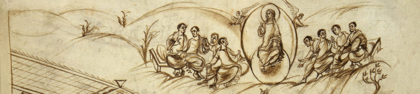
Roald Dijkstra, Radboud Universiteit Nijmegen
Pierre et ses miracles du rocher : l’influence du contexte géographique
La fameuse scène du miracle du rocher de saint Pierre est une des scènes les plus souvent représentées de l’art paléochrétien. L’interprétation de cette scène énigmatique continue à être discutée à cause de l’absence d’une source littéraire antérieure ou contemporaine aux représentations visuelles.
L’abondante bibliographie sur le sujet témoigne d’une recherche d’un prototype et d’un interprétation unique pour la scène. Il semble, pourtant, que le problème ne soit pas abordé efficacement. La différence entre les représentations du miracle (le nombre des soldats en train de boire, la représentation du Christ ou d’un arbre, les légendes, etc.) peut être expliquée d’une façon plus productive si on considère la possibilité que des versions différentes aient existé.
La légende littéraire des saints Processus et Martinien est romaine d’origine, située dans un contexte topographique clairement romain, et la plupart des représentations du miracle du rocher ont été faites à Rome. Pourtant, la scène est aussi montrée sur des objets qui étaient commandés et répandus en dehors de la région de la ville éternelle, par exemple sur des sarcophages en France et dans la péninsule ibérique. Des versions clairement déviantes sont montrées sur deux plats conservés à Obernburg et Saint-Pétersbourg. Cette communication étudie la possibilité d’une plus grande variété de versions de la légende du miracle du rocher de Pierre et l’influence du contexte géographique sur le mode de représentation de cette scène.
Federico Caruso, Pontificio Istituto di Archeologia Cristiana; Université Paris-Sorbonne
Osservazioni sulla topografia di Siracusa: spazi ed infrastrutture pubbliche tra Insula e Achradina in epoca tardoantica
I processi di trasformazione del paesaggio urbano di Siracusa durante l’epoca tardoantica non sono di facile lettura e ancora oggi le ricerche più recenti non hanno fornito una chiara interpretazione riguardo al rapporto tra la città vera e propria e l’immediato suburbio. Tuttavia alcune variazioni del profilo planimetrico intercorse tra il III e il IX secolo, benché attestate parzialmente dalle testimonianze archeologiche, sono individuabili grazie allo studio combinato delle fonti materiali e letterarie.
Il presente contributo propone di revisionare e aggiornare gli studi pregressi fornendo una nuova interpretazione della topografia siracusana. In particolare, l’analisi si concentra su alcune strutture pubbliche di primaria importanza nell’area di confine tra Insula e Achradina: le due maggiori infrastrutture portuali e lo spazio dedicato all’esercizio dell’amministrazione pubblica. Alcuni importanti indicatori di continuità segnalano la persistenza nell’uso delle unità topografiche prese in esame.
La vitalità nei commerci della città siciliana garantì un flusso di merci, persone e idee senza interruzioni dall’epoca classica al pieno medioevo, che resero Siracusa un punto di contatto cruciale nella geografia del Mediterraneo antico. A questo proposito, si legano un passo del Bellum Gothicum di Procopio, alcuni riferimenti contenuti nella Vita di san Villibaldo, gli episodi narrati nella celebre epistula del monaco Teodosio al momento della conquista araba della città (878) e infine la descrizione degli approdi redatta da Al-’Idrīs nella prima metà del XII secolo. Inoltre, alcune osservazioni inedite sull’ubicazione della residenza del potere d’epoca tardoantica e bizantina si ricavano dallo studio delle fonti letterarie cristiane antiche. I nuovi orizzonti di ricerca avvicinano Siracusa alle grandi metropoli dell’Orbis, soprattutto sul piano della codificazione del paesaggio e dello spazio urbano, confermandone l’identità peculiare di punto nevralgico tra centro e periferia del mondo antico.
Ruth Kolarik, Colorado College
Canopies over baptismal fonts: Structure and function. Examples at Stobi (FYR Macedonia) and elsewhere
In keeping with the elaboration of ecclesiastical architecture in the sixth century the font of the Baptistery of the Episcopal Basilica at Stobi was embellished with an elaborate canopy comprising two sets of impost capitals made for that purpose, columns and bases. The longer columns were set onto the pre-existing mosaic floor and the shorter ones were placed on the rim of the font according to a reconstruction by W. Dinsmoor, Jr. It was probably a freestanding canopy rather than the structural support that he proposed, however. When the canopy was built semi-circular niches and a white marble and black slate revetment were also added to the font. At about the same time the baptistery of the North Basilica, also at Stobi, received a niched font with a similar black and white revetment and a ciborium supported by six purple marble columns.
Remains of stone ciboria survive in many other baptisteries. The columns were either placed on the floor around the font (Salona) or on the rim of the font itself (Aquileia). The pairing of larger and smaller columns is unusual if not unique. Such structures must have added visual drama to the ceremony of baptism and may also indicate changes in the baptismal ritual. Images in other media give some sense of their appearance. These ciboria may have emulated the structure of more elaborate baptisteries such as the Lateran baptistery, remodeled in the fifth century, or the baptistery at Butrint where structural columns surrounded the font.
Stanislav Stanev, Institute of Art Studies – Bulgarian Academy of Science, and Jeni Tankova, Regional Archaeological Museum in Plovdiv
The Episcopal Basilica of Thracian Philippopolis (Plovdiv, Bulgaria)
The Episcopal Basilica of Thracian Philippopolis has a long exploration history. Started in 1983 and continued till 1985, the archaeological excavations has revealed nearly the southern half of a vast three ailed basilica with one apse on east, and a peculiar atrium, preceding it from west. Floors of both nave and aisle, as well as of atrium’s porticos and southern rooms, were made of mosaics, preserved almost everywhere. Results are soon after communicated on XI CIAC and elsewhere.
Initialized in 2015, with a large scale mosaics conservation project, the exploration of the site has been resumed. In the process of cleaning and detaching from terrain of the latest floor’s mosaic, two different mosaics are discerned. That of the nave is the earliest in date, while that of the aisle was commissioned by a certain bishop as his donor inscription in tabula ansata testifies.
Between 2016 and 2017 the northern half of the basilica was excavated. In size enormous – nearly 36 m width and more than 85 m long if calculated with the atrium, the basilica encroached one insula and partially another, both occupied by public buildings, most probably religious. Besides its structural periodization, pointing to an early foundation date, and its mosaic floors of 4th, 5th and 6th c., the basilica’s liturgical plan is of a particular interest: the apse was designed as a non-restricted passageway towards a veneration point, which is to be located right behind the raised platform of the presbytery.
Ljuben Tevdovski, Goce Delčev University of Štip
Floral and Zoomorphic Motifs in South Balkans Early Christian Art as Indicators for the Process of Shaping of Early Christian Dogma in the Wider Spiritual Koinē
South Balkans represents an important integral part of the wider Eastern Mediterranean region that produced the economic, social, political, ideological and spiritual preconditions and circumstances that nurtured Christianity, its worldviews, dogmas, rituals, institutions and wider practice. The wider process of transformation that intensified in this region in the third century BC resulted in strong philosophical, ideological, political and religious tendencies towards monotheism and monarchism.
Today, while we are aware of the transformative nature and continuity of the concepts for society, arts, spirituality and religion in the Classical, Hellenistic, Roman, Late Antique and Medieval periods the traditions of the professional history of archaeology still create boundaries and even bias approaches to this unique and complex process of transformation.
In this context, the Early Christian Art and the wider archaeological material from the Late Antiquity provide in important link that that possesses capacities to bridge over our academic misconceptions created in the early enthusiastic stages of our efforts to anticipate our modern identity through archaeological and cultural heritage.
This study makes an effort to anticipate the transformations of the mythological symbols, representations and concepts in Early Christian Art through analyses of the decorative and architectural ornaments found in early Christian basilicas and related archaeological contexts in three different South Balkan countries. While it examines the technological, artistic and functional transformation of the material, the main focus is to add additional light and clarity to the process of shaping of the early Christian dogma in the wider eastern Mediterranean spiritual koinē.
Tomislav Fabijanic, University of Zadar
A church in a church: Smratina on the island of Vir (Croatia)
Vir is an island approximately 30 km to the NW of Zadar (lat. Iader), one of the most important early Christian centres on the eastern Adriatic coast. Furthermore, Vir has been a part on Nin (lat. Aenona) municipal territory, another important Roman and early Christian centre. However, although Vir’s position and its rich history suggest that there should be some archaeological sites it has evaded attention of archaeologists until very recently. In 2013, University of Zadar in collaboration with Archaeological museum Zadar has started excavation of Smratina site. Its very name is indicative for early Christian or early medieval period because it traces its origin to Saint Martin. Indeed, on the site churches from both periods have been found, one built inside the other. Larger church with polygonal apse can be attributed to the early Christianity (6th century) and the smaller one most likely belongs to the early medieval period. Of special importance are the remains of early Christian altar screen especially a pilaster with the name of the sculptor Marcilianus. Early Christian church is 1-nave building with two adjacent chambers built on the north side, as well as a narthex and exonarthex on the west side. The latter were used for burials. The church has been built in three phases. In the graves around the church, additional graves have been found containing early Byzantine jewellery. Also, worth mentioning is a solidus of Justinian I.
Božana Maletić, University of Zadar
Ager Salonitanus – vita alla frontiera
Una nuova ricerca archeologica condotta nell sito di Biranj sulla sommità della collina di Kozjak permette di indagare alcuni importanti aspetti della vita della periferia del centro cristiano di Salona. Nel sito, di plurisecolare frequentazione, è stata infatti messa in luce una fortezza tardoantica che, dalla sua posizione privilegiata, risponde pienamente alle esigenze di protezione dei fertili campi ai piedi della collina e in generale delle risorse naturali del territorio; nello stesso modo, dobbiamo immaginare una sua coordinata azione di monitoraggio del territorio per una fruibilità efficace dei precoci siti cristiani dell’Ager Salonitanus.Con il presente contributo si cercherà di individuare, attraverso una’analisi dei resti materiali, il rapporto di interdipendenza che intercorre, in età tardoantica, tra gli abitanti dell’ager e la fortezza: un rapporto simbiotico che ci parla dello sfruttamento agricolo di un territorio, della sua protezione e della sua connessione interna verso siti di forte richiamo cultuale. Un’idea di periferia molto fluida e multisfaccettata quindi, dove i confini naturali e artificiali apparentemente prefissati possono restringersi o dilatarsi in relazione alle esigenze degli abitanti e alla capacità difensiva del sistema centrale.
Nicola Busino, Università della Campania Luigi Vanvitelli, and Antonio Salerno, Polo Museale della Campania
Alla periferia di Capua vetus: aspetti della cristianizzazione di alcuni ‘centri minori’ della Campania settentrionale
Recenti ricerche nei territori a nord di Capua hanno evidenziato tratti significativi delle dinamiche di cristianizzazione di questo settore della Campania, caratterizzato da un’infrastruttura viaria ancora pienamente funzionante e perfettamente in grado di assicurare i contatti tra le aree campane e Roma.
La progressiva organizzazione dello spazio cristiano venne certamente agevolata anche dalla riforma amministrativa di Diocleziano che fece di Capua la sede del governatore della Campania nel IV secolo: la presenza di un ceto aristocratico che svolse un ruolo primaziale nell’ambito dei nuovi quadri dirigenziali fu certamente il presupposto che assicurò la nascita ed il consolidamento di un’élite ecclesiastica molto intraprendente, ben nota ad esempio attraverso le intraprese edilizie per Capua. Per quanto riguarda i settori della Campania settentrionale, un caso emblematico è certamente quello molto conosciuto del mosaico dell’Epifania proveniente da un’area funeraria ubicata nel suburbio di Teanum Sidicinum: accanto agli intrinseci valori qualitativi del manufatto e ai suoi significati iconologici molto forti, recentemente ribaditi da Fabrizio Bisconti, esso documenta le connessioni dei committenti locali – un ramo della gens Geminia – con alcuni settori dell’Africa Proconsolare nella seconda metà/fine del IV secolo.
Attraverso l’analisi delle questioni circa l’organizzazione delle sedi episcopali, la definizione delle aree cimiteriali (comunitarie ma non solo), gli aspetti devozionali e cultuali, le identità delle committenze dei centri diocesani di Suessa (Sessa Aurunca), Teanum Sidicinum (Teano), Cales (Calvi Risorta) e di altri sedi minori, è stato possibile mettere a fuoco molti spunti per la conoscenza degli aspetti della cristianizzazione di queste aree marginali, apparentemente ubicate in territori di transizione ma in realtà perfettamente integrate nella nuova Italia cristiana.
Chiara Cecalupo and Axel Alt, Pontificio Istituto Archeologia Cristiana
Letters from the frontier: rediscovery of Christian antiquities by religious missions at the borders of Christian world
In last centuries, religious missions in Middle East and Mediterranean basin have supported archaeological and ethnological expeditions. In North-Africa this connection was very strong during the 19th century and it is possible to say that religious groups played a key-role in rediscovering the rich historical past of the area from Algeria to Tunisia. This helped North-Africa to become of fundamental interest in researches of Christian archaeology in the final decades of the 19th century, when this discipline was getting stronger due to the incredible amount of discoveries that had been simultaneously taking place in Rome.
This poster aims to underline this historical issue by showing an unpublished original letter found by the authors during a research undertaken in the Historical Archive of the Congregation de Propaganda Fide in Rome. This long letter was written from Tunis in 1880 by the Abbot Labouille, who wanted to inform the Congregation about the brand new discovery of Christian antiquities in El-Kef (Sicca Veneria). Written in Latin, the precious text reports the founding of architectural remains of two cult buildings and some inscriptions, that help investigating the early-Christian past of the city. This letter is important to understand the long life of the notable architectural Christian complex of el-Kef; in addition, it is a special proof of history of Christian archaeology researches in a border region at the end of the 19th century, when the studies of the Early-Christianity start to seriously involve, for the first time, the areas outside Rome.
Margherita Riso, The University of Edinburgh
Archaeological approaches to the Christianisation of Sicily, a region between centre and periphery (6th-7th centuries): a new distribution map of rural churches in light of recent discoveries
In the aftermath of the Byzantine acquisition of Sicily in 535, the Roman Church gained a leading position in the rural administration and landholding system of the former Late Antique senatorial latifundia. The Sicilian rural landscape was then reorganised in massae and vici, also known as “agglomerati secondari”, which were the main elements of the settlement network. The numerous places of Christian worship, both urban dioceses and rural parishes, are known especially through Pope Gregory the Great’s epistolae. They acquired a central position in fostering the aggregation of scattered peasant communities, playing a central role in the collection of land-tax revenues. Currently, the archaeological remains of about 40 rural churches dating to the 6th-7th centuries are known from Sicilian villages. Although the investigation of these structures is of paramount importance in order to achieve a full understanding of the Christianisation of Sicily, a region between centre and periphery, the last systematic study to focus on this topic dates back to 1999. Through the systematic collection and critical review of recently published discoveries, the aim of this Poster is to create an up-to-date distribution map of Byzantine rural churches in Sicily, aiming to investigate the socioeconomic role of these religious institutions within and beyond the cura animarum of local peasant communities. I will argue that factors like safety, proximity to main roads, and strategic location within the networks of agricultural resources, were all crucial aspects in the diffusion and distribution of rural churches in Sicily.
Konstantin Voronin and Mariya Kabanova, Institute of Archaeology, Russian Academy of Science, Yaroslavl State Technikal University
Roman silver bowl for the quinquennalia of Caesar Licinius II from Asia Minor
This bowl, ca. 321 C.E., is stored in the collection of the Heritage Foundation (Moscow, Russia). Very slightly ovoid, measuring 18.9cm in diameter and weighing 283 grams. Historical, art, chemical and physical methods of research were used in the study of this subject. The tondo is stamped with the facing draped and cuirassed bust of the emperor Licinius I, around which is the inscription “LICINIVS AVG OB D V LICINI FILI SVI”: “Licinius Augustus (presented this) on account of the quinquennalian day of his son Licinius.”. A small circular stamp (7 mm in diameter) on the exterior surface near the edge reads: “NK (ligatured) O/AI/ MEB in three lines, indicating that is an official product of the Nicomedia mint. It is known that donative bowls like this also presented during festivities. But only four of them have survived. Three another bowls came to light in the so called “Munich treasure”. Licinius II was proclaimed Caesar in 317 C.E. immediately after his birth. The quinquennalia of the Caesar Licinus II was celebrated after 1 March 321 C.E., apparently anticipating the actual fifth anniversary of his elevation, which fell on 1 March AD 322 C.E. The anniversary is commemorated on aurei of Nicomedia and of Antioch, which formed part of emperors’ largess on this occasion. The fate of Caesar Licinius II was sad. He was killed in 327 C.E., when Roman Empire was united under the authority of the Emperor Constantine.
Nicolas Beaudry, Université du Québec à Rimouski; Dominic Moreau, Université de Lille; Georgi Atanasov, Regionalen istoricheski muzey – Silistra, Bulgaria; Valeri Yotov, Regionalen istoricheski muzey – Varna, Bulgaria; Albena Milanova, Sofiyski universitet “Sv. Kliment Ohridski”, Bulgaria; Brahim M’Barek and Ioto Valeriev
Zaldapa in Late Antiquity: Archaeological Perspectives on a fortified Christian City of the Lower Danube’s Hinterland
With its fortifications defending 25 ha of a densely built plateau, Zaldapa (Krushari, Bulgaria) is the largest known Romano-Byzantine stronghold of the hinterland of Scythia and Moesia Secunda. The city was known as the birthplace of general Flavius Vitalianus († 520), who rebelled against emperor Anastasius and contributed to the rise of the Justinianic dynasty; whether it was an episcopal see, as mentioned in later sources, is open to debate. The city is thought to have been abandoned in the late sixth or early seventh century, in the context of the Avar and Slavic migrations. The site was never reoccupied and offers thus a remarkable archaeological potential, that has remained hardly explored to this day. It was first explored between 1889 and 1910 by Karel and Herman Škorpil, who planned the city walls, excavated a basilical church and identified a second one. Since 2014, Georgi Atanasov and Valeri Yotov have been excavating a third, larger church thought to be the city’s cathedral, as well as an earlier church lying underneath. An international team will be joining the Bulgarian team in 2018 to contribute to the investigation of the late antique city itself. This poster will focus on the results of preliminary work by the international team, including an updated city plan based on satellite imagery and field investigation, and on its forthcoming investigation of the dynamics of the Christian and military landscapes of late antique Zaldapa.
Claudia Dobrinski, University of Paderborn, and Sveva Gai, Stadtarchäologie Paderborn
Bishop Meinwerk of Paderborn as a builder: Local, ancient and foreign elements in the architecture of the beginning of the 11th century
The archaeological investigations since the post-war period which led to the discovery of the Charlemagne-founded Palatine and the existing of the Royal Palace until the end of the 12th century, as well as the excavations at Abdinghof and in the Cathedral District, the Chapel of Bartholomew: These are very important to reconstruct the early and high medieval architectural history of Paderborn.
In 806 Charlemagne founded the diocese of Paderborn, an important church and power politics field office of his empire against the Saxons. The geographically and politically exposed situation meant that the respective bishop has to preserve and expand the Roman-imperial claim, which has testified by the frequent stays of the emperor in that Palatinate.
Emperor Henry II instituted Meinwerk as the bishop of Paderborn (1009-1036) – the Capellan and a close confidant of the Emperor, a court versed, theologically educated and wealthy nobleman.
Immediately after taking office Meinwerk started to build a magnificent Paderborn with numerous construction work: the new building of the cathedral, the episcopal as well as imperial palace, the fortress of the Cathedral, the Chapels of Bartholomew (per operarios graecos ), which represented the public place of the imperial ceremonial in the palace complex. In the West the Benedictine monastery of (a more romano) and in the East the Canon Church Busdorf (Church of the Holy Sepulcher, Jerusalem) were symbolizing the imaginary church cross.
This poster presents the recent researches, particular paid attention to the adoption of foreign (Roman and antique) elements in the architecture of the beginning of the 11th century, and the influence and determination to the local craftwork.